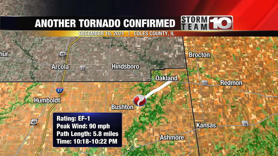
OAKLAND, Ill. (WTHI) - The National Weather Service has confirmed an additional tornado touched down in Coles County on Dec. 10, 2021.
The weather service said the twister touched down a quarter mile east of the community of Rardin and traveled 5.8 miles before lifting one mile east of Oakland.
"The tornado did only tree damage with the greatest concentration of tree damage through the wooded areas along the Embarras River," the NWS wrote in its storm report. "Evidence that the tornado was on the ground was also found along East County Rd 1750 N."

It doesn't look like much, but a pine tree northeast of Rardin lost its top in the Dec. 10 storms. The NWS believes it was caused by an EF-1 tornado.
Meteorologists rated the tornado an EF-1 on the Enhanced Fujita scale and estimated peak wind gusts to be 90 mph.
James Auten, senior forecaster with the Lincoln, Ill. NWS office, said it's more difficult to find tornadic damage in rural areas during the winter months, especially if the tornado was weak.
He said trees can withstand the wind gusts and not break since they don't have leaves and empty fields make it a challenge to determine a path.
Auten said radar data was analyzed to help confirm a tornado touched down in the area that night.
The Oakland tornado is now the second of three tornadoes that touched down in the Wabash Valley on Dec. 10.
The first tornado, later rated an EF-2, touched down in Shelby Co., Ill., and crossed three counties before lifting northwest of Mattoon, damaging several structures and homes in its path.
Then, after producing this latest confirmed tornado near Oakland, the storm moved into Edgar County where it dropped another EF-2 tornado northeast of Chrisman, damaging machine sheds and grain bins.
Click here to read all of NWS Lincoln's storm surveys from the night.


